Dhaulagiri Round Trek, Dhaulagiri Trekking, Trekking Dhaulagiri Base Camp

Dhaulagiri Round Trek

Book this trip
A brief in details

overview

Dhaulagiri Round Trek

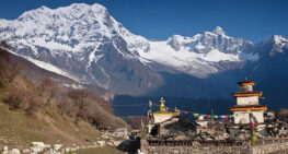
Dhaulagiri Round Trek is a challenging Trekking in Nepal. Dhaulagiri Mountain is the highest peak lying in the North-west of Pokhara Valley. The height of Mt. Dhaulagiri is 8,167m/26,795ft this mountain deception in the south of Tibet. The Dhaulagiri along with another eight thousand-meter Peak Called Annapurna I, These two high peaks carve the world’s deepest Gorge of Kaligandaki River.
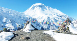
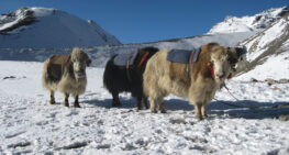
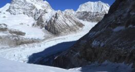
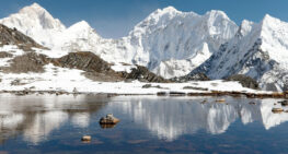
Dhaulagiri Trek crosses two high Passes French Pass 5,240m and another Thapa Pass 5155m. Moreover, we will also experience snow and Glacier walking especially around the Italian Base camp and Dhaulagiri North base camp. Along the way, we enjoy spectacular views of Dhaulagiri, Annapurna, Kaligandaki River with its deepest gorge, and Thorong Peak. On the trail, we may also meet wild yak herds, and mountain sheep in the remote valley of this region. Besides the wild nature, we also enjoy the shops, tea houses, and lifestyle of Nepal’s ethnic people such as Bahun, Chhetri, Gurung, Magars, and more.

Dhaulagiri Circuit Trek

Dhaulagiri  Round Trek begins from Beni. So, in the morning we a take a bus or van to drive from Kathmandu and the first night we will spend in Beni.  Beni is the headquarters of the Magdi district. We will stay one night and the trek starts from next day.
The first few days of the trek pass through cultivated fields connected to some of the mountain villages. As we ascend to the Italian Base camp, the climb begins to get tougher after Dobhan. The trek continues to the Iced French and Thapa Passes which have to be scaled before we descend a winding trail to Yak kharka, after a long Descent we will be at Marpha Popular town in Mustang District. From this Juncture, we follow the classical Annapurna trail to Jomsom to Pokhara and fly the next Day.

The Final and scenic drive from Pokhara to Kathmandu concludes the trek. Nepal Holiday trips provide other treks in Annapurna Reason Trekking, Jomsom Muktinath Trek, Ghorepani poon hill Trek, etc.

view the

Itinerary

S. N |
On arrival at Kathmandu Tribhuvan International Airport, you will be received by our staff who will escort you to the Hotel, where one of our staff will give you a brief orientation of the Hotel, Kathmandu, Trekking do's and don't, and other related information that you might require while you are in Nepal.
Take a drive up from Kathmandu to Beni via Baglung it is quite an interesting drive from Kathmandu to Pokhara and Pokhara to passing through numerous towns and villages with a superb panorama of snow-capped peaks of Annapurna and Manaslu range as the journey continues leaving the suburb of Pokhara, after an 3-4 hours drive coming to the busy town of Baglung. As the new road to Beni was completed a few years back, continue another hour or two rides to Beni with a brief stop on the route. Beni a large town, the headquarters of the Myagdi district. There is quite a lot of traffic of many porters' mules and donkey trains carrying loads of merchandise on the Kali Gandaki route. Our overnight camp is just a little away from the main village.
The way after Beni enters westwards, following the course of the Myagdi River upstream, through lush verdant landscape, with rice paddies and dense sub-tropical forest on the steeper higher slopes. The morning walk passes through some small farm villages. Our journey continues passing several farm settlements till overnight camp at Babiyachaur is reached, a small village with a couple of local teahouses with a small ground just by the trail. Once a year, people from around this area host an auspicious fair as per the Hindu religious calendar. The camp is set with time for a cool splash down the River Myagdi.
The trail along the Myagdi River is prone to landslides during the monsoon season and there are many upon to bi-pass sections of the path that have been disrupted. The walk continues to follow the river upstream passing through several small settlements after 3 hours or less of a good walk arriving at a large interesting village of Darbang, where we might stop for lunch depending upon the time of our walk. After lunch, cross the Myagdi river over the suspension bridge, the trails wind up gradually for an hour up to Phedi meaning the bottom of the hills or pass, after leaving the river behind a steep climb of one and a half hour reaches us to the cooler region at the ridge, then a short easy walk will bring us to the village at Dharapani, stunning views of Putali and Ghurja the western peaks adjoining Dhaulagiri massif can be seen from the campsite at Dharapani.
From Dharapani, the path follows along the farm fields and to the snout of the ridge where Dhaulagiri Himal is visible. Then the trail leads to a descent towards the Gatti Khola, from here two hours of steady climb lead us the to large village of Mure for the overnight camp, at the confluence of the Myagdi and Dhara rivers. The Dhara River flows from the west, in which direction lays the important regional bazaar town of Dhorpatan en route to the Dolpo region. The Myagdi flows down from the north and this is the river valley which we will be following to its source near Dhaulagiri Base Camp.
Our route skirts around and descends to the warm areas of paddy fields on a partially penetrated by the tributary Dhora Khola. After crossing Dhora Khola, the main path ascends the hillside, passing the rural farmhouses, and goes through a hamlet to an up-and-down mountain path then skirts around the ridge. The path continues winding steep uphill for two hours and coming at the top of the ridge, the path descends gradually to a small farm village at Bagar after six hours of good walk. Bagar is the last village en route before Marpha village is reached at the Kali-Gandaki valley. Camp is made at the premises of the primary school ground.
From today onwards for a week in total isolation in the perfect tranquility of the harsh and beautiful wilderness amidst the lofty Dhaulagiri range, leaving the Bagar village behind and its farm fields following the path through the forest which climbs on the west side of the river Myagdi, trek follows the narrow undulating trail above the river Myagdi, reaching the ridge top, then the path descends steeply in some section coming to a clearing where we find some stone built Shepard's huts. Gradually ascending, encounter the grassy clearings and after a total of 5 to 6 hours of peaceful walk reaching a level ground of grassy field 'Kharka' named as Dovan for the overnight camp.
From the camp at Dovan our route follows the path to the river after less than 30 minutes of walking, then coming to the bank to cross Konaban Khola, depending upon the level of the river, sometimes the bridge will be high on the top of the huge boulder or when the level of the water is low can be easier crossing just on the plank or logs. If the bridge is high above the river crossing would be quite daring on the rickety temporarily built bridge, after the bridge the walk follows through the forest for a while then crossing another log over the tributary stream then once again entering the forested area until the ascent becomes a descent, and from here one can see the west wall of Dhaulagiri I, between the breaks of the trees. Then heading down to Myagdi Khola side take the left bank path, and climb up towards another khola called the Pakite Khola, without ever getting too far from the Konaban river, crossing this little stream -Pakite Khola to the tableland of Chartare, or the Bhainsi Kharka and camp for the night.
Leaving the campsite, continue following the trail ahead leading to the forest area known as Italian Base Camp. The trial heads into a rocky area and then climbs the mountainside with a steep hill at the end. After crossing the steep hill, the path narrows then crosses and descends to the other glacier that originated from the West wall of the Dhaulagiri, then climbs the opposite bank to a wide grassy area in a narrow gorge valley of Pakhaban, also known as Japanese Camp. Pakhaban is a beautiful campsite with an impressive West wall of Dhaulagiri I and to the rear the huge stone walls from Tsaurabong Peak.
Today, an early move for the Base Camp is situated at 4,750 meters. Following a lateral moraine from Pakhaban to a rocky ridge that descends to the right side of the valley buried in snow and fallen rocks. Entering the glaciated area from the rocky right side banks, walking along the undulating glacier surface as the valley bends to the right bank route with a short up-and-down passage to Dhaulagiri Base Camp situated at 4,750 meters high. Looking up at the impressive North face of Dhaulagiri I, while to the west the peaks of Dhaulagiri II (7,751 m.), III (7,715 m.), and IV (7,618 m.) stand soaring to the sky, and before us are the desolate Ice Fall dropping form the col between Dhaulagiri and Tukuche Peak. Overnight camp will be made on the clearing of the rocky moraine with an awesome close view of Dhaulagiri I and its massif glacier and icefall.
From Dhaulagiri Base Camp, the journey continues leading us to the moraine and glacier, the path follows close to Tukuche Peak. After the glacier, climb a rocky terraced hill on the right bank side, climbing the hill which runs along the glacier for a short while, then again climb to another higher hill across the mountain flank, entering a gentle slope on the right side of the valley and further, climb up to French Col at an elevation of 5,360 meters. On reaching the highest point of this journey at French Pass where the Buddhist prayer flag or lung-ta is hoisted by fellow trekkers and climbers respecting the mountain spirit. This vantage point offers a stunning view of the mountain ranges including - Sita Chuchura, the mountains of Mukut Himal, and Tashi Kang (5,386 m.), all of which surround the Hidden Valley. To the right is Tukche Peak west and to the rear stands the huge Dhaulagiri I. A gentle descent along the snow-covered landscape finally leads to the overnight halt at the wide Hidden Valley. This Valley remained behind the Dhaulagiri massif undiscovered, until the last few decades. It offers a very scenic charm with several small Peaks to climb.
Contingency or a reserve day, in case there's a problem or difficulty on route. If we are on schedule with our program we will have a rest day here to explore this Hidden Valley, depending upon the weather as well.
After a wonderful time at Hidden Valley, the adventure continues to cross Dhampus Pass at 5,250m. Trek follows on the gradual path for an hour with a short climb in between, the path gets narrow on the scree section for an hour, then towards the high traverse across Dhampus Pass at 5,250m overlooking the deep cleft of the Kali Gandaki Valley and the Annapurna peaks beyond. Reaching the top of the ridge at Dhampus Pass, a view of Mukut Himal is visible from the pass as the Hidden Valley is overlooked behind the Col. It's a steep hill along the rock covered mountain side until we reach our campsite at Yak Kharka. Yak Kharka, a summer pasture of the villages down below Kaligandaki Valley areas, Dhaulagiri I is hidden by the bulk of Tuckche Peak, but Nilgiri and the western end of the Annapurna massif are visible.
This morning walk leads towards a steep down along the narrow mountain path up to a ridge from where Dhaulagiri I and the Tukche Peak become visible again. Today follow the path on the left banks along the Kali Gandaki River up to Tukuche Village, where in the past it is said that Tibet, India trade once had flourished. Following the winding mountain trail that goes downwards to the right side and crosses a stream to reach a little settlement of Alubari consisting some number of small stone huts. Winding around further and keeping still to the right, descend a steep zig-zagging along the narrow mountainside. The final descent eventually reaches the center of the village of Marpha and continues to walk to Jomsom.
Today we are taking a flight to Pokhara and during the daytime, we can do sightseeing around Pokhara and relax around Fewa Lake boating.
Explore around tourist place Thamel for your shopping as you need or if you want to do a world heritage sites tour we will provide you experience tour guide for explaining the historical things.
Our staff will drop you at the International Airport for your further travel or back home.
Trip cost

Includes & Excludes

Cost Includes

  • All transfer airport to Hotel
  • Two Night Hotel in Kathmandu with B.B plan
  • All Accommodation and three times food during the Trek
  • Tourist Bus to Pokhara
  • An experienced English speaking Government license holder Trekking Guide
  • Two people get one porter
  • Guide and porter salary, their food and accommodation in mountain
  • All necessary paperwork and permits for Annapurna Conservation Area and TIMS
  • A comprehensive medical kit-box
  • All government and local Taxes

cost excludes

  • International and national airfare
  • Excess baggage charges
  • Lunch and dinner in Kathmandu
  • Extra night accommodation in Kathmandu and Pokhara
  • Travel Rescue insurance
  • Personal expenses like Phone calls, Laundry, Extra drinks, Battery charge, Wi-Fi, extra porters, hot and cold water, Hot shower
  • Tips for Guide, Porter, and Driver, it is mandatory
Note: The above Itinerary can be customized to your needs. Your Accommodation will provide as your exact requirement. Please let us know whether you would like to make a shorter or longer. We will follow your request.
Write a review
we are associated with Nepal Government NTB TAAN NMA KEEP